On Sunday morning, President Trump sent out the following tweet regarding Hurricane Dorian: “In addition to Florida — South Carolina, North Carolina, Georgia, and Alabama, will most likely be hit (much) harder than anticipated,” he wrote. “Looking like one of the largest hurricanes ever. Already category 5. BE CAREFUL! GOD BLESS EVERYONE!”
Less than half an hour later, the National Weather Service (NWS) Birmingham issued a rebuttal tweet: “Alabama will NOT see any impacts from #Dorian. We repeat, no impacts from Hurricane #Dorian will be felt across Alabama. The system will remain too far east,” NWS Birmingham tweeted.
After slamming the Bahamas as a category 5 monster, Hurricane Dorian made a northward turn, skimmed the Florida coast, and is currently churning up the Eastern Seaboard.
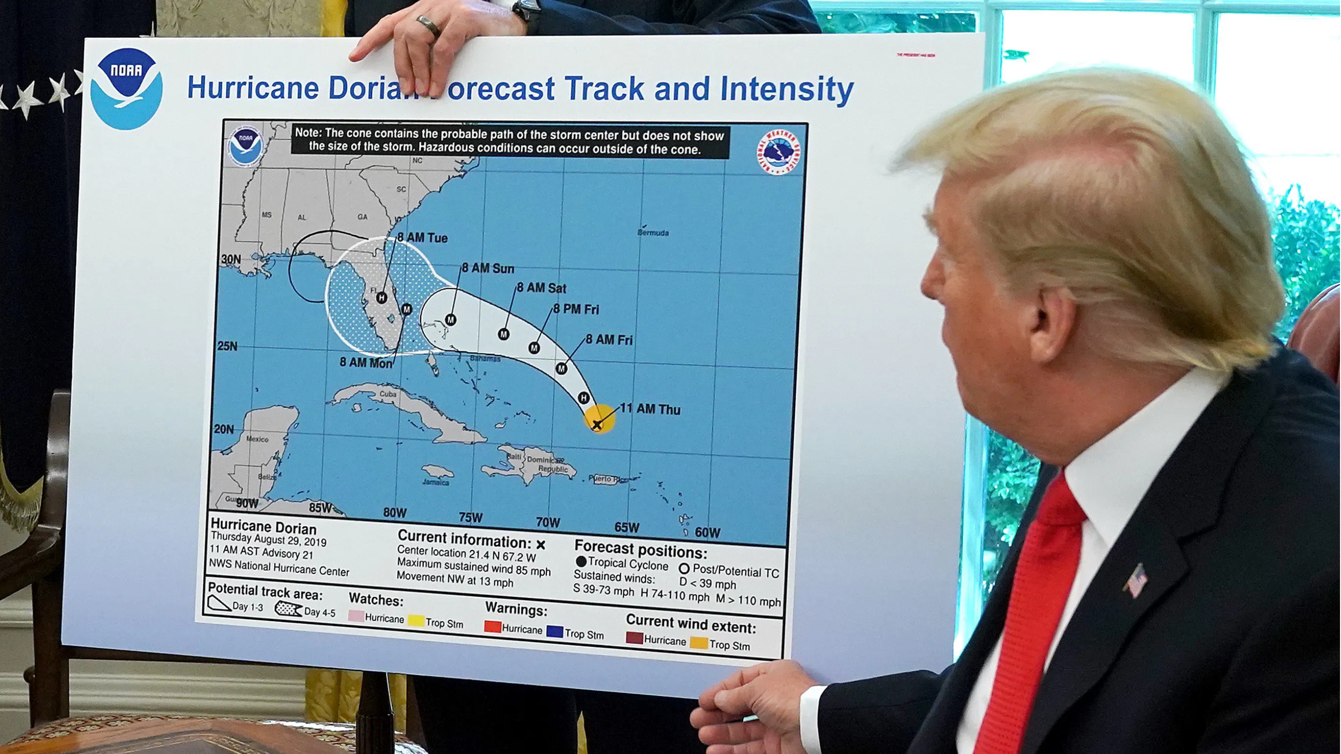
On Wednesday, during a briefing held in the Oval Office, the president displayed a poster-board featuring the projected path of Dorian as predicted by the National Hurricane Center as of last Thursday.
On top of the original image, which showed Dorian’s predicted path through the following Tuesday, it looked as though a hand-drawn bubble extending the affected area to include the state of Alabama had been added using black marker.
Holding the display, President Trump said:
We got lucky in Florida. Very, very lucky indeed. We had actually — our original chart was that it was going to be hitting Florida directly … and that would have affected a lot of other states. But that was the original chart, and you see it was going to hit not only Florida, but Georgia. It could have … was going toward the Gulf — that was what we, what was originally projected, and it took a right turn, and ultimately, hopefully we’re going to be lucky. It depends on what happens with South Carolina, North Carolina.
A reporter later asked the president about the apparent Sharpie add-on: “[When] you showed us the map earlier, the original forecast of it, it appeared to have been, I guess, edited or something to include Alabama. Can you explain how that change was made?”
Trump replied:
No. I just know … that Alabama was in the original forecast. They thought it would get it, as a piece of it. Actually, we have a better map, which is gonna be presented, where we had many lines going directly — many models, each line being a model — and they were going directly through. And in all cases, Alabama was hit, if not lightly, in some cases pretty hard. Georgia, Alabama — it was a different route. They actually gave that a 95% chance probability. It turned out that that was not what happened; it made the right turn up the coast, but Alabama was hit very hard, was going to be hit very hard.
Pressed again on the “Sharpie,” the president said: “I don’t know. I don’t know.”
The Associated Press notes: “The highest probability issued for a U.S. locale for Dorian has been in the 60% range, not 95%.”
In the face of scrutiny regarding his assertions about Dorian making an impact on Alabama, President Trump continued to defend himself.
“Such a phony hurricane report by lightweight reporter @jonkarl of @ABCWorldNews,” he tweeted. “I suggested yesterday at FEMA that, along with Florida, Georgia, South Carolina and North Carolina, even Alabama could possibly come into play, which WAS true. They made a big deal about this when in fact, under certain original scenarios, it was in fact correct that Alabama could have received some ‘hurt.’ Always good to be prepared! But the Fake News is only interested in demeaning and belittling. Didn’t play my whole sentence or statement. Bad people!”
On Wednesday, the president tweeted a “spaghetti” model created by the South Florida Water Management District (SFWMD) from August 28 in which several of the numerous paths Hurricane Dorian could have taken had it seemingly impacting the state of Alabama.
“This was the originally projected path of the Hurricane in its early stages,” he wrote. “As you can see, almost all models predicted it to go through Florida also hitting Georgia and Alabama. I accept the Fake News apologies!”
User @morten hit back, tweeting, “Not so fast, Sharpie! You used a map stamped August 28 (lower left corner). Your erroneous tweet was sent September 1. You ‘informed’ the population with a four days old weather forecast?”
The Associated Press quotes hurricane researcher Brian McNoldy, who said of the president’s spaghetti map: “He has no clue what he’s talking about, or what is plotted on that map. At the time of that cycle, Alabama was at even lower risk than before, and it was barely anything to start with.”
Additionally, at the bottom of the spaghetti map, it states: “NHC [National Hurricane Center] advisories and County Emergency Management Statements supersede this product. This graphic should complement, not replace, NHC discussions. If anything on this graphic causes confusion, ignore the entire product.”
The Daily Wire reached out to the South Florida Water Management District in order to find the model the president used on his Twitter feed, but as of publication, we have not received a reply. However, there were several spaghetti models from late-August that showed similar results:
On Wednesday, the idea was floated that the president, or the individual who altered the map, may have broken the law.
The Washington Post’s Aaron Blake pointed to a 1948 law (18 U.S. Code § 2074) that reads: “Whoever knowingly issues or publishes any counterfeit weather forecast or warning of weather conditions falsely representing such forecast or warning to have been issued or published by the Weather Bureau, United States Signal Service, or other branch of the Government service, shall be fined under this title or imprisoned not more than ninety days, or both.”
Hurricane Dorian is “about 55 miles south-southeast of Myrtle Beach, South Carolina, and 105 miles south-southwest of Wilmington, North Carolina,” reports CBS. Meanwhile, the devastation from the hurricane is still being assessed in the Bahamas, where “the official death toll rose to at least 23 Thursday. The Red Cross said nearly half of the homes on the Abaco Islands and Grand Bahama were damaged or destroyed.”
Dorian is currently a category 2 storm, and is expected to make landfall in North Carolina today or Friday.
.png)
.png)